Today’s cities and towns need smarter, more efficient ways to plan roads, bridges, utilities, and public spaces. As communities grow, so does the need for reliable data to guide development. That’s where LiDAR mapping comes in.
LiDAR mapping gives planners and engineers precise, real-time elevation data. It’s helping to transform how we design, manage, and upgrade infrastructure—saving time, cutting costs, and preventing errors before construction begins.
Why LiDAR Mapping Matters for Infrastructure
LiDAR mapping gives planners and engineers access to fast, accurate elevation data that’s critical for designing infrastructure the right way—before the first shovel hits the ground.
With this technology, teams can detect subtle terrain changes, plan around slopes, and model how water will move across a site. That level of detail allows for smarter decisions about road grading, utility placement, and stormwater systems—long before costly problems appear during construction.
More and more cities and contractors are turning to LiDAR solutions for infrastructure projects to reduce guesswork, improve accuracy, and complete builds on time and within budget.
Key Infrastructure Applications of LiDAR
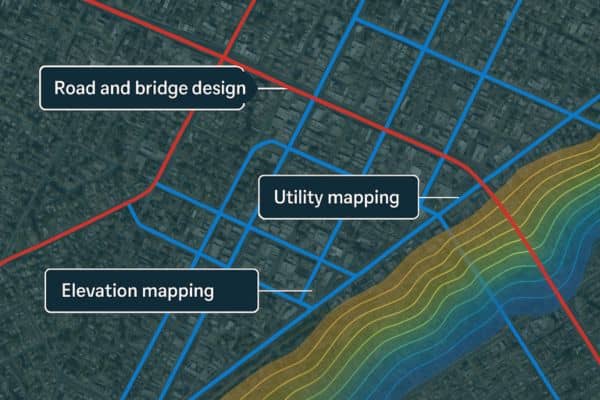
📍 Road and Bridge Design
LiDAR data helps engineers design roads and bridges that follow natural land contours. It reduces the need for guesswork and manual measurements.
🌧️ Stormwater and Drainage Systems
Planners use LiDAR to see where water will collect or flow after rain. This helps design storm drains, swales, and retention areas that prevent flooding.
🔌 Utility and Right-of-Way Mapping
LiDAR shows existing utility lines, poles, and access paths. This prevents mistakes when placing new infrastructure like water pipes, power lines, or fiber cables.
Supporting Urban Growth with Elevation and Terrain Data
As cities expand into more complex terrain, advanced site planning with LiDAR mapping allows engineers to understand slope and elevation changes more clearly and avoid costly grading surprises.
This is especially helpful when choosing where to build new roads or subdivisions. LiDAR helps avoid costly grading, retaining walls, or drainage redesigns later in the project.
LiDAR in Transportation Planning and Traffic Engineering
🚦 Corridor and Intersection Design
Accurate surface data improves road alignment, traffic light placement, and sidewalk slope.
🚶 Pedestrian and Bike Path Planning
LiDAR maps help cities design safe, ADA-compliant walkways and bike lanes with the right slope and drainage.
These insights make travel safer and smoother for everyone.
Improving Flood Mitigation and Drainage Infrastructure
Flooding is a major concern in many regions, especially as weather patterns become more unpredictable. Engineers rely on elevation data for infrastructure planning to model flood risks accurately by identifying how and where rainwater naturally flows across a site.
With this information, engineers can:
- Predict ponding and overflow areas
- Size storm drains correctly
- Comply with FEMA floodplain regulations
- Protect neighborhoods from water damage
Integration with GIS and Civil Engineering Tools
LiDAR data is easily added to software like GIS, CAD, and 3D modeling tools. This allows teams to:
- Design roads, drainage, and structures with greater precision
- Share accurate maps between engineers, architects, and agencies
- Speed up approvals and reduce design changes mid-project
The result is a more connected, efficient planning process.
LiDAR for Infrastructure Upgrades in Older Areas
Many older neighborhoods have roads and utilities built decades ago—often without digital plans. LiDAR mapping helps fill the gaps.
Cities and contractors use LiDAR to:
- Map existing streets and curbs
- Identify erosion or settling in pavement
- Plan utility upgrades with minimal digging
This helps maintain aging infrastructure while minimizing disruption.
Benefits for Local Governments and Developers
For municipalities and private developers alike, LiDAR mapping brings major advantages:
✅ Faster project start times
✅ Lower surveying costs
✅ Fewer construction delays
✅ Improved safety and compliance
When decisions are backed by accurate terrain data, projects are more likely to stay on track and under budget.
FAQs About LiDAR in Infrastructure Planning
1. Is LiDAR more accurate than traditional surveys?
Yes. LiDAR typically offers elevation accuracy within a few centimeters, especially when processed properly.
2. Can LiDAR be used in both rural and urban areas?
Absolutely. It works well over forests, farmland, cities, and construction zones.
3. How long does a LiDAR survey take?
A drone-based LiDAR survey can often be completed in hours, with data processed in just a few days.
4. Does LiDAR help reduce construction mistakes?
Yes. By providing clear elevation and surface data, LiDAR prevents errors in grading, drainage, and utility placement.
5. Can LiDAR data be used for permitting?
Yes. Many local governments accept LiDAR-backed site plans as part of development applications.
6. Is LiDAR expensive?
While there’s an upfront cost, LiDAR often saves money by avoiding delays, rework, and field visits.
