land surveying
LiDAR Mapping in the AI Era: Faster, Smarter Site Data
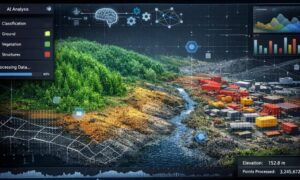
Most people think lidar mapping simply means scanning land with lasers and turning it into a 3D model. For many years, that description worked. However,
Most people think lidar mapping simply means scanning land with lasers and turning it into a 3D model. For many years, that description worked. However,

When Nashville’s winter storm arrived, life across the city slowed almost at once. Roads turned slick. Power outages spread from street to street. Businesses closed

If you work with property, construction, or development, you may have noticed quiet discussions online about federal mapping data. At first, this topic may seem